iMeasurer
Accurately measure distance using GPS

Screenshots of iMeasurer

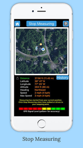


Accurately measures walking, jogging, running or riding distance, using your mobile GPS. Displays your current latitude, longitude, altitude, heading and speed. Map shows current location and a compass. When measuring has completed all of the details are copied to the clipboard. Shows maximum speed and keeps track of your measurement history.
This is a universal app, buy it once, use on the iPad, iPhone and iPod Touch.
Features:
- Display current location address
- Map features layered on top of a satellite image showing current location. Map compass shown.
- Start measuring to indicate the starting point to measure from. Start measuring also resets max speed.
- When measuring, distance from the starting location is displayed. If are measuring a long distance, e.g. in auto, miles and meters are used.
- Stop measuring for final distance calculation. When measuring has completed, all of the details are copied to the clipboard for convenience.
- Show measurement history. Shows all your measurements with a date/time stamp. Can clear history or copy a measurement details to the clipboard.
- Latitude of current location is always displayed
- Longitude of current location is always displayed
- Altitude of current location is always displayed
- Speed traveling (mph and kph)
- Maximum Speed. Starting a measurement resets the maximum speed.
- GPS signal strength indicator. Note: The better the GPS signal the more accurate the measuring is.
- Map zoom
- Small and large map display mode
- Map pinch and swipe motions used for zoom in, zoom out and pan
Note: Continued use of GPS running in the background can dramatically decrease battery life.